Philadelphia’s trolley system, operated by SEPTA’s Metro division, is a historic and vital part of the city’s public transportation. The network blends underground streetcar tunnels in Center City with surface-level tracks extending into West Philadelphia and Delaware County. Known as the Subway–Surface Trolleys or simply the “T,” the system provides a convenient, affordable, and often scenic transit option for thousands of riders daily.
For detailed maps and schedules, visit SEPTA’s official trolley information page at septa.org and explore route maps at SEPTA Maps & Schedules.
Overview of the Trolley Network and Routes
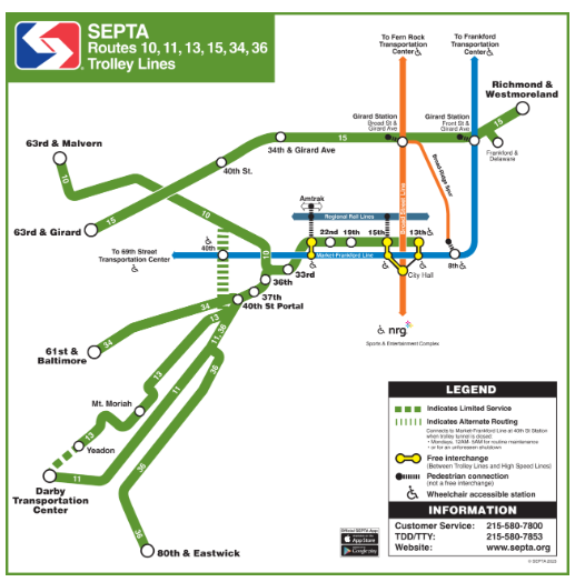
The trolley system consists of five main routes, numbered T1 through T5, which operate along overlapping paths through Center City and then diverge to serve distinct neighborhoods and suburbs:
- T1 (Lancaster Avenue Line): Begins underground at 13th Street in Center City, surfaces near 36th Street, and travels northwest on Lancaster Avenue through neighborhoods like Belmont and Overbrook.
- T2 (Girard Avenue Line): Runs alongside Girard Avenue after surfacing, serving neighborhoods in North and West Philadelphia.
- T3 (Chester Avenue Line): Serves the southwestern neighborhoods and extends into Delaware County along Chester Avenue.
- T4 (Woodland Avenue Line): Travels through West Philadelphia and continues into Darby in Delaware County, serving residential and commercial areas.
- T5 (Eastwick Line): Extends farther southwest, serving the Eastwick neighborhood and access points near Philadelphia International Airport.
The five trolley routes collectively cover approximately 40 miles of street-level tracks combined with several miles of subterranean transit tunnels. This legacy system is one of the few remaining street-running urban trolley networks in the United States.
Center City Tunnel and Surface Transition
Trolleys running underground enter at 13th Street, loop under City Hall, stopping at stations such as 15th Street, 19th Street, 22nd Street, 30th Street, and 33rd Street. Several tunnels also provide access to University City near 36th Street, Drexel University, and the University of Pennsylvania.
Just beyond 36th Street, most trolley routes emerge onto surface tracks via portals around 36th and 40th Streets, dispersing onto their different surface routes that lead to their respective neighborhoods and suburban termini.
Connections and Transfers
Passengers enjoy numerous convenient connections:
- Transfer free of charge to the Market-Frankford Line (the “El”) at 13th, 15th, and 30th Streets.
- Connect to the Broad Street Line subway at 15th Street for north-south travel.
- Access SEPTA Regional Rail services through underground passageways near 13th and 15th Street stations to Suburban Station and Jefferson Station.
- Link with bus routes and airport shuttles at surface stops along the trolley lines.
For exact route maps and each stop, consult the detailed maps available on septa.org maps page, which include urban, suburban, and legacy trolley line maps.
Rolling Stock and Future Upgrades
The current LHVs (Light Rail Vehicles), originally introduced in the early 1980s, provide reliable service but are scheduled for an upgrade, with new low-floor Alstom trolleys expected to begin arriving from 2027 to improve accessibility and rider comfort. These low-floor vehicles will enhance boarding efficiency, particularly for riders with disabilities.
Riding Tips and Accessibility
- Check real-time arrival information and service alerts on SEPTA Real Time System Map.
- All trolley vehicles are equipped with low-floor access and priority seating.
- Plan transfers carefully for rides connecting to other transit modes, especially during weekend or evening hours when service levels may differ.
Unique Features and Historic Significance
Philadelphia’s trolley routes are remnants of an expansive pre-World War II streetcar system and preserve much of the city’s transit character. The mix of underground operations in Center City with street-level travel through neighborhoods provides an experience that combines efficiency with a window into Philadelphia’s urban fabric.
SEPTA’s trolley network is an essential part of Philadelphia’s transportation ecosystem, seamlessly connecting neighborhoods, suburbs, and central business districts. Whether commuting or exploring the city, riding the trolleys offers a direct, economical, and authentic Philadelphia transit experience.
For more information on routes, schedules, real-time updates, and maps, visit the official SEPTA trolley page at septa.org, utilize their interactive maps at SEPTA Maps & Schedules, and check live vehicle tracking on the Real Time System Map.
Have any thoughts?
Share your reaction or leave a quick response — we’d love to hear what you think!
-
 0
0
-
 0
0
-
 0
0
-
 0
0
-
 1
1
-
 0
0